Lassen Volcanic National Park
A mountain. A volcano. A story. Hidden in the backbone of the Sierra Nevada, Lassen Volcanic National Park is an amazing combination of extremes. Hot and cold. High and low. Big and small. The moment you stop into the park, you are immersed in a variety of wildlife and a sense of how small humans really are compared to this world.
Lassen is located at the very northern end of the Sierra Nevada range, and also at the very southern end of the Cascade Range, and encompasses 106,452 acres. The main feature of the park is Mount Lassen, the largest plug volcano in the world, and the southernmost volcano in the Cascade Range. Lassen Volcanic is one of the few areas in the world where all four types of volcano can be found (plug dome, shield, cinder cone, and strato). And with 536,068 visitors to Lassen in 2016, it is a relatively solitary park.

Between 3 and 4 million years ago, volcanic-derived mud flows called lahars flowed down several major mountains that included nearby but now extinct Mount Yana and Mount Maidu to become the Tuscan formation. Basaltic and later andesitic to dacitic flows of lava covered increasingly larger areas of the Tuscan formation to eventually form the lava plateau that the park sits on. Around 600,000 years ago, Mount Tehama started to rise as a new stratovolcano in the southwestern corner of the park, eventually reaching an estimated 11,000 feet in height. Following a series of eruptions approximately 350,000 years ago, its cone collapsed in on itself to form a 2 mile wide caldera.
Between 385,000 and 315,000 years ago, volcanism at the Lassen center shifted from andesitic stratovolcano construction to the forming of dacite lava domes. Over the past 300,000 years, the Lassen Peak area has produced more than 30 lava domes with Lassen Peak being the largest. These lava domes formed as a result of rising lava that was pushed up but was too viscous to escape its source, creating steep formations.
Roughly 27,000 years ago, a dacite lava dome quickly pushed through Mount Tehama’s northeastern flank to become the approximately 1,000 feet shorter Lassen Peak. Lassen’s shape was greatly altered by glacial erosion from 25,000 to 18,000 years ago during the Wisconsin Glaciation. Since then, smaller dacite domes such as the 1,100-year-old Chaos Crags have formed around Lassen. Steam explosion eruptions (aka Phreatic) eruptions, dacite and andesite lava flows, along with cinder cone formations have continued into modern times. Most notable of these are the mid to late 17th century eruption and formation of Cinder Cone and the May 1915 eruption of Lassen Peak. Since then, the only volcanic activity has been the constant bubbling of mud pots and steaming of fumaroles in Lassen Volcanic National Park’s various geothermal areas.

The areas surrounding Lassen Peak, represented a meeting ground for the Maidu, Yana, Yahi, and Atsugewi Native Americans. The volcano is known among the Native people as “Fire Mountain”. They inhabited the areas around Lassen long before white settlers saw the area. They also knew that the peak was full of fire and water, and would one day blow apart. But because the Lassen Volcanic area was not suitable for permanent population, there is relatively scarce archeological information of a native presence in the park.
The first white explorer to reach Lassen Peak was Jedediah Smith, who passed through the area in 1821 as he made his way to the west coast. After the California Gold Rush, many settlers came to the area, and Lassen Peak was named in honor of Peter Lassen, a Danish blacksmith who guided immigrants past the peak to the Sacramento Valley in the 1830s. The Nobles Emigrant Trail, named for the guide William Nobles who pioneered the trail, was cut through the park in 1851 and passed Cinder Cone and the Fantastic Lava Beds.
Inconsistent newspaper reports from 1850 to 1851 from witnesses described seeing “fire thrown to an terrible height” and “burning lava running down the sides” in the area of Cinder Cone. As late as 1859, a witness reported seeing fire in the sky from a distance, attributing to a eruption. Early geologists and volcanologists who studied Cinder Cone concluded the last eruption happened between 1675 and 1700. After the 1980 eruption of Mount St. Helens, the United States Geological Survey (USGS) began reassessing the potential risk of other active volcanoes in the Cascade Range. Further studies of Cinder Cone estimate that the last eruption was between 1630 and 1670. Recent tree-ring analysis shows that the eruption was in 1666.
The first ascent of Lassen Peak happened in 1851, and was led by Grover K. Grodfrey, and in 1864, Helen Tanner Brodt became the first woman to reach the summit of Lassen Peak, wanting to sketch the surrounding landscape. A tarn lake on Lassen Peak, “Lake Helen” is named after her.

Bumpass Hell, a geothermal hotspot near Lassen Peak, and it is named after Kendall Vanhook Bumpass, a cowboy and early settler who worked in the Lassen Peak area in the 1960s. He discovered the area and was named on a mining claim. In 1964, an editor of the Red Bluff Independent newspaper took a trip with Bumpass to see the geothermal area. During this trip, Bumpass fell through a thin crust above a scalding hot mud pot and burned his leg badly; it later had to be amputated.
The Lassen Peak area was first designated as the Lassen Peak Forest Preserve. In May 1907, Lassen Peak and Cinder Cone were designated as U.S. National Monuments by President Theodore Roosevelt.

Between May 1914 and 1921, Lassen Peak underwent a series of eruptions that created a new crater, and also released a ton of lava and ash. Fortunately, because of warnings, no one was killed, although several houses along area creeks were destroyed.
On May 14, 1915, Lassen Peak erupted lava blocks, which extended as far as Manton, 20 miles west of the mountain. By the next day, the volcano had produced a dacitic lava dome, between 63 and 68 percent silica, which occupied its summer crater.
On May 19, a large eruption destroyed this dome, and a new crater appeared at the summit. No lava erupted, but parts of the dome fell on the upper flanks of the mountain, which at the time were covered with more than 30 feet of snow. The lava mixed with snow and rock to form a lahar (a volcanically induced mudslide, landslide and debris flow), a half-mile in width, which coursed down the sides of the volcano, traveling 4 miles and reaching Hat Creek. After being deflected to the northwest at Emigrant Pass, the lahar extended another 7 miles along Lost Creek.
On May 20, muddy water flooded the Hat Creek valley, damaging ranch houses and causing minor injuries among a few people, all of whom escaped. Removing homes from the foundation, the lahar also uprooted trees more than 100 feet. The flood continued for another 30 miles, killing fish in the Pit River. At the same time, dacite lava with lower viscosity than dacite from the previous eruption filled the summit crater, overflowing and extending in 2 streams for 1,000 feet down both the mountain”s western and northeastern.
On May 22, at about 4:00 pm, Lassen Peak produced another massive explosive eruption that ejected rock and pumice and formed a larger and deeper crater at the summit. Within 30 minutes, volcanic ash and gas formed a column that reached altitudes of more than 30,000 feet and could be seen from the city of Eureka, 150 miles away. The column underwent a partial collapse, creating a pyroclastic flow composed of hot ash, pumice, rock and gas that destroyed 3 square miles of land and spawned a lahar extending 15 miles from Lassen Peak and again reaching Hat Creek Valley. Smaller mudflows also formed on every side of the mountain, as well as a layer of pumice and ash that stretched 25 miles northeast; volcanic ash was detected 280 miles east at the city of Elko, Nevada. Additionally, the lava flow on Lassen’s northeastern side was removed by this eruption, but not the similar flow on the western flank.

The eruptive output volume totaled 0.07 cubic miles, dwarfed by the 1980 Mount St. Helens eruption, which had a volume of 0.24 cubic miles. The area on the volcano’s northern flank destroyed by the eruptions, 3 square miles in area, is now known as the Devastated Area, and it along with other deposits of the volcano has been altered by erosion and the regrowth of vegetation. The vegetation in the Devastated Area is sparse though, due to its siliceous (rich in silica), nutrient-deprived soil, which cannot sustain normal tree growth due to its lack of water retention. And also, due to their small size and thin deposits, the 1915 eruptions will likely not be preserved well geologically.
After 1915, steam explosions continued for several years, indicating very hot rock still active underneath Lassen Peak’s surface. In May 1917, an extremely strong steam explosion formed the northern crater on Lassen’s summit, with eruptions lasting two days and producing an ash cloud that rose 10,000 to 12,000 feet into the sky. June saw 21 additional steam explosions, further altering the crater and forming a new vent on the northwestern summit. In June 1919, steam eruptions continued, and similar activity was observed on April 8 and April 9 in 1920, followed by steam eruptions lasting 10-12 hours in October 1920. In February 1921, white steam exploded from eastern fissures on the mountain.
In total, 400 eruptions were recorded between 1914 and 1921, which were the last eruptions in the Cascades before the 1980 eruption of Mount St. Helens, which was the only volcanic eruption in the contiguous United States during the 20th century.
Because of eruptive activity and the area’s stark volcanic beauty, Lassen Park, Cinder Cone, and the surrounding area were declared a National Park on August 9, 1916.
The 29-mile Main Park Road was constructed between 1925 and 1931, just 10 years after the eruption of Lassen Peak. Near Lassen Peak, the road reaches 8,512 feet, making it the highest road in the Cascade mountains. It is not unusual for 40 feet of snow to accumulate on the road near Lake Helens and for snow to last into July.

In October 1972, a portion of the park was designated as the Lassen Volcanic Wilderness by the U.S. Congress (Public Law 92-511). The National Park Service (NPS) seeks to preserve the wilderness in keeping with the Wilderness Act of 1964, with minimal developed facilities, signage, and trails. The management plan of 2003 states that, “The wilderness experience offers a moderate to to high degree of challenge and adventure.
In 1974, the NPS took the advice of the USGS and closed the visitors center and buildings at Manzanita Lake. The survey stated that the buildings would be in the way of a rockslide from Chaos Crags if an earthquake or eruption occurred in the area. An aging seismograph remains there though. However, a campground, store, and museum dedicated to Benjamin F. Loomis stands near Manzanita Lake, welcoming visitors who enter the park from the northwest entrance.
After the Mount St. Helens eruption in 1980, the USGS intensified its monitoring on the active and potentially active volcanoes in the Cascade Range. Monitoring of the Lassen area includes periodic measurements of ground deformation and volcanic gas emissions and continuous transmission of data from the nine seismometers in Lassen to the USGS offices in Menlo Park, California. Should indications of a significant increase of volcanic activity be detected, the USGS will immediately deploy scientists and special portable monitoring systems to evaluate the threat. In addition, the NPS has developed an emergency response plan that would be activated to protect the public in the event of an impending eruption.

The park is located at the northern end of the Sacramento Valley, and since most of the park is medium to high elevations, Lassen generally has cool-cold winters and warm summers below 7,500 feet. Above this elevation, though, the climate is harsh and cold, with cool summer temperatures.
The western part of Lassen Volcanic National Park, great lava pinnacles (large mountains created from lava flows), jagged craters, and steaming sulfer vents. It is cut by glaciated canyons, and is dotted and threaded by crystal-clear lakes and rivers.
The eastern part is a vast lava plateau more than one mile above sea level. Here, small cinder cones are found (Fairfield Peak, Hat Mountain, and Crater Butte). Carpeted with forests of pine and fir, this area is also plentiful in small lakes, but has few streams. Warner Valley, marking the edge of the Lassen Plateau, features many hot springs and thermal areas (Boiling Springs Lake, Devils Kitchen, and Terminal Geyser). This forested valley also has large meadows that bloom with wildflowers in the spring.
The magma that fuels the volcanoes in the Lassen area is derived from a subduction off the coast of Northern California. Cinder Cone and the Fantastic Lava Beds, located about 10 miles north of Lassen Peak, is a cinder cone volcano and the associated lava flow that last erupted about 1650. The eruption created a series of basaltic-andesite to andesite lava flows known as the Fantastic Lava Beds.
During the Ice Ages, glaciers have modified and helped to erode and shape the older volcanoes in the park. The snow accumulation and therefore ice radiation was Lassen Peak, Red Mountain, and Raker Peak. That is why these mountains have more glacial scarring than other volcanoes in the park. Despite not having glaciers, Lassen Peak has 14 permanent snowfields.
Lassen Volcanic National Park gets more precipitation than anywhere else in the Cascades south of the Three Sisters, and is due to the lack of a rain shadow from the Coast Ranges. Snowfall at the new visitors center at the southwest entrance at 6,700 feet is around 430 inches, despite facing east. Up around Lake Helen, at 8,200 feet, the accumulation is around 600-700 inches, making it probably the snowiest place in California. Snowbanks persist year round by the lake.

The road rolls up and down through a seemingly never-ending forest. The trees march past in an evergreen blur and the clouds float merrily through the bright blue sky. The road ends at a lake bustling with people swimming, canoeing, kayaking, and fishing. Kids laugh and squeal happily and parents prepare picnics on tables by the lake.

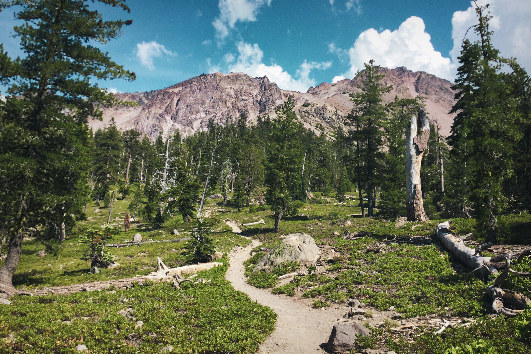
We continue on though, and arrive at a trailhead just off the side of the road. The trail is marked by one small sign at the edge of a little gravel parking area, and would be easily missed if you weren’t looking. We started out as the trail slowly climbed up across a meadow, and soon, we entered the shade and solitude of the forest.
Only two people have passed us so far, going up to the top. The forest underbrush opens up to a pine needle blanket surrounding the base of the trees. Chipmunks scurry through the undergrowth and chatter to each other in the silence of the forest. The trees whisper secrets to the others in the wind, and a hummingbird pauses its rapid flight to rest on a bush.

We hike even higher, the trail steepening, our feet carrying us faithfully along the path. My brother and I climb ahead of everyone and stop for a moment under the shade of a pine tree.
Ants dutifully march in a line, gathering food for the colony. A woodpecker drums on a tree, looking for lunch.
We continue on our trek.
The forest opens up and gives way for a beautiful meadow filled with wildflowers. The small dirt path weaves up through the flowers toward a jagged peak, silhouetted by the dark rain clouds behind.

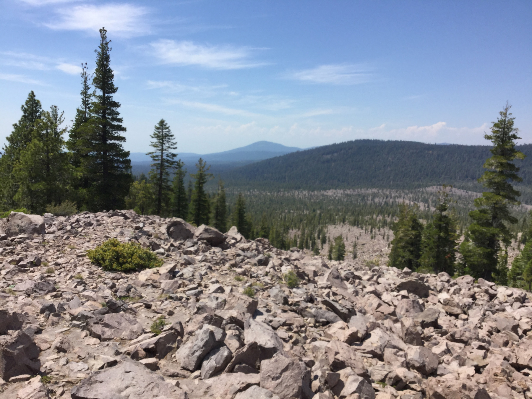
The trail finally reaches the top, a rockfield beneath the shadow of the peak.
We sit down to take a rest for a moment, listening to distant thunder, and watching clouds form over the mountain.

A chipmunk was curious and comes out from his rocky home to check us out. He watches us warily and seems to see we weren’t a threat. He continues on his quest to find food.
The wind soars over the mountain, lifting an eagle higher and higher toward the clouds, and swoops down, rustling through our hair and the trees.
Sitting up on the rocks, listening to nature, is a sure way to reconnect with your roots.
The thunder comes closer, so we decide to head back down the slope.
As we reach the bottom, I reflect on the trail and the encounters with nature. I realize that the clouds had parted again, leaving the day bright and sunny.
We climb back into the car and go over to the lake where all the hustle and bustle was. It makes me realize that solitude isn’t far away and connecting with nature is also not far off.

As we leave the park and head home, I know that nature isn’t our enemy, it isn’t just a thing to be used. When you spend some time in nature, you realize nature is your friend.

Nature is your family.